Додати об'єкт до каталогу

Надсилайте актуальну інформацію та отримуйте більше цільових клієнтів. Ми розмістимо ваш об’єкт у нашому каталозі та покажемо поруч із локаціями, а також у загальному каталозі, це безкоштовно!

Lake Ivor (Dragobratske)

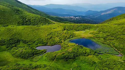
Dragobratske Lake (Ivor) is a high mountain lake of glacial origin in the Ukrainian Carpathians, in the Svidovets massif. It lies at an altitude of 1,600 m above sea level, in an elongated depression, among the northern slopes of the Blizniuki mountain, within the Rakhiv district of the Zakarpattia region.

The length of the lake is 55 m, the width is 21 m, the area is 0.1 ha. The depth is up to 1.2 m. The shores consist of moraine. It feeds on soil and atmospheric waters. The water is clear, slightly mineralized. The bottom is covered with gray silt. The banks are overgrown with sedge. Of the ichthyofauna, only microscopic crustaceans are found.
Озеро Івор

Photo and video of Lake Ivor

A brief overview

🗺 Location 48°13’42″N 24°14’5″E
💧 Maximum depth 1.2 m
🌊 Area of ​​the reservoir 0.1 ha
🧭 Distance from Dragobrat 3.5 km
🚙 Road for Car, on foot
🏕 Stand with a tent Yes
🏡 Housing nearby Dragobrat
☕ Cafes and shops Dragobrat

How to get to Lake Dragobratske

 Walking route

🔰 Start From the cradle of shepherds
🚶 Walking distance 750 m
⬆ Rise from 1447 to 1602 m
🕒 Approximate travel time 17 min.

On the map

What is interesting nearby

Other interesting places

Tours and excursions

Accommodation nearby

Leisure nearby