🕒 Date of last update of the article: 07.01.2024 at 8:36 p.m | 🖋 Author: Viktor Shatrov
Надсилайте актуальну інформацію та отримуйте більше цільових клієнтів. Ми розмістимо ваш об’єкт у нашому каталозі та покажемо поруч із локаціями, а також у загальному каталозі, це безкоштовно!
🕒 Date of last update of the article: 07.01.2024 at 8:36 p.m | 🖋 Author: Viktor Shatrov
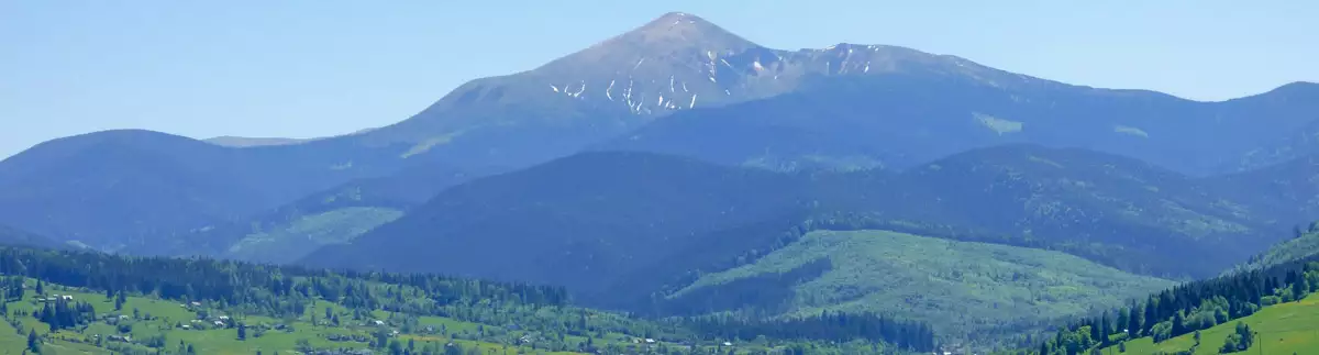
If not everyone is destined to climb the highest point in the world – Mount Everest, then every tourist can climb the highest point in Ukraine – Mount Hoverla. Mount Hoverla is located within two Ukrainian regions – Transcarpathia and Ivano-Frankivsk, and it is 17 kilometers from the border with Romania.
Despite the fact that the height of Hoverla is 2061 meters, this does not stop those who want to get a boost of energy and enjoy the incredible panorama that opens not only on the top, but also on way to her. And the ascent can be done on your own, if you have sufficient experience, or you can entrust the entire organization of the ascent to Hoverla to the KULUAR club.

Content
| 🗺 Location | N48°07’21.9132″ E24°26’50.7274″ |
| ⛰ Highest point | Hoverla (2061 m) |
| 🏔 Spine length | 40 km |
| 🧭 Distance from Lazeshchyna | 17 km |
| 🚙 Road for | On foot, partly by SUV |
| 🏕 Stop with a tent | Yes |
| 🏡 Housing nearby | Lazeshchyna |
| ☕ Cafes and shops | Lazeshchyna, Zaroslyak |
The temperature in Hoverla now:
The shape of Hoverla (Transcarpathian region) is a cone-shaped mountain covered with alpine meadows and somewhere shrubs. In some places, there is a loose stone, which will not interfere with the ascent at all, if you choose the right shoes. It is near this mountain that the Prut River originates, so, if you wish, you can enjoy the beautiful waterfalls near Hoverla with a total height of 80 meters.
If you have enough energy, desire and good weather, you can explore the entire Chornohirsky ridge, Kolomyia, Ivano-Frankivsk and the Pip Ivan observatory. At the very top there are alpine grasses, and a flagpole with the flag of Ukraine is also installed. A cross and a trident are installed here. The peak used to serve as the border between Poland and Czechoslovakia, so there is still a memorial obelisk here.
There are several routes to Mount Goverla and they all have the same length – from 10 to 16 kilometers, and the ascent – from 1150 to 1350 meters. It is recommended to choose different routes for ascent and descent, which will allow you to see the view from Hoverla from different angles. After spending the night in tents or in private estates, the next day you can climb Mount Petros, which is slightly inferior to Hoverli in terms of height.
For travelers, Hoverla (or as some call it “Noverla”) has already become so familiar that they don’t even remember how the name of the mountain came about. According to one of the versions, the name came to us from other languages, for example, if we take the Romanian language, the name is translated as “difficult climb”.
If the name is translated from Hungarian, it translates as “snow peak”. And this is not surprising, because in fact 9 months a year there is snow on the top, and sometimes even in summer. But let’s try to find out a few legends that will tell about the mysterious and mystical events that caused the appearance of this mighty peak.
There is no direct bus or train to the foot of Hoverla. The most convenient option is the Vorokhta station. From there you need to get to the checkpoint, which you can do on foot, by car or by taxi. You will need to show your ID at the entrance.
It is 8 kilometers from the checkpoint to the Zaroslyak tourist base. From there, paying attention to the markings on the trees, you can go to the top on the blue or green route. The latter is the easiest, but longer, and the other is more difficult, but faster. But, in any case, take more photos of Hoverla so that you can enjoy her beauty even at home.
If you decide to travel by bus, you can get to Vorokhta from Lviv, Kyiv, Ivano-Frankivsk and Uzhgorod. Trains passing through Vorokhta are Lviv-Rakhiv, Kyiv-Rakhiv, Ivano-Frankivsk-Vorokhta/Rakhiv.
When traveling by your own transport, you need to take the route Kyiv-Zhytomyr-Ternopil-Frankivsk-Nadvirna-Yaremche-Vorokhta. At the intersection, turn right onto Hoverlyanska Street. And from it there is a direct road to the Zaroslyak tourist base.
Now we’ll describe the best hiking routes to Hoverla, and you just have to choose which route to Hoverla will suit you. We will also try to describe the advantages, and you yourself determine how to climb Hoverla and what the optimal starting point is.
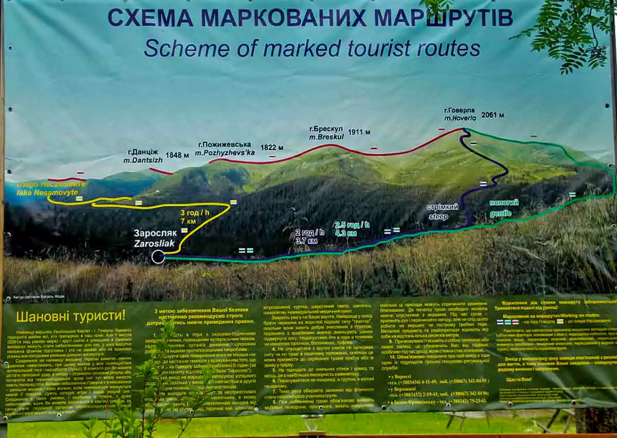
It is about 19 km from Vorokhta to the “Zaroslyak” base, of which there is an asphalt road, and then there is a dirt road, where you can drive an SUV without problems, and it is a little more difficult to drive a car, but you can also drive.
Further from Zaroslyak only on foot. Ascent and descent can take about 4-6 hours.
| 🔰 Start | Vorokhta or Zaroslyak |
| 🚙 Distance by SUV from Vorokhta to Zaroslyak | 19 km |
| 🚶 Walking distance from Zaroslyak | 3.5 km |
| ⬆ Rise | from 1262 m to 2061 m |
It is 10 km from Lazeshchyna to the Kozmeschyk tract. This road can be overcome by a passenger car, but an SUV can be driven without any problems.
In Kozmeschyk, you can find a place for a tent or stay in a guest house, there are several of them. You can be deliciously fed there. And from Kozmeschyk it is only a walk. The ascent is not easy, but it is a very beautiful road, with many picturesque places and stops.
| 🔰 Start | Lazeshchyna |
| 🚙 Distance by SUV to Kozmeschyk | 10 km |
| 🚶 Walking distance from Kozmeschyk | 7 km |
| ⬆ Rise | from 719 m to 2061 m |
If you are travelling by off-road car, you can reach the Kozmieszczyk tract from Lazieszczyn, and then go up the slope to the right, about 7 km to the Golowczeska meadow. From the skirts it is easy to climb Hoverla and Petros.
This route is interesting because the ascent to Hoverla is easy enough, even easier than the one from Zaroslyak, but it is less popular because you can reach the mountain valley only by four-wheel drive.
| 🔰 Start | Lazeshchyna or Polonina Holovschyna |
| 🚙 Distance by off-road vehicle from Lazeshchyna to Poloniny Holovceska | 17 km |
| 🚶 Walking distance from Polonina Holovceska | 6,5 km |
| ⬆ Climb | from 1400 m to 2061 m |
A little-known route from the village of Shybene, as this route is the longest.
Shibene is the outermost village from Vorokhta towards Verkhovyna, and then to the right. Minibuses go here very rarely, but the interest of this route is that there is no sharp rise and on the way you can visit several lakes, namely Lake Marycheyka, Brebeneskul and on the lake Nesamovyte. If necessary, stop at the observatory “White Elephant“. Sometimes this is really necessary, as on one of our walks at the end of June we got caught in a blizzard and the temperature dropped below zero. Many of our company simply did not have warm clothes with them and the Slon base helped them warm up.
| 🔰 Start | Shybene |
| 🚶 Walking distance | 26 km |
| ⬆ Rise | from 860 m to 2061 m |
There is also a little-known route from the Hoverla village of the same name.
Hoverla is the farthest village from Rakhov. However, this route is interesting in that part of it can be traveled by minibus from Rakhov, and if you are on an SUV, then you can go as fast as possible to the top, and then walk.
| 🔰 Start | Hoverla |
| 🚶 Walking distance | 11 km |
| ⬆ Rise | from 700 m to 2061 m |
The route from Dzembronia is interesting because we take a minibus from Vorokhta to the village of Dzembronia and then walk about 21 km through beautiful places.
This route is interesting because it doesn’t take long to get to the village where you start, and then you can walk along beautiful mountain paths.
| 🔰 Start | Dzembronia |
| 🚶 Walking distance | 21 km |
| ⬆ Rise | from 740 m to 2061 m |

The highest peak of the Ukrainian Carpathians is Mount Hoverla, the height of which is 2061 meters. There is a legend that in ancient times, when our region was part of the Hungarian Kingdom, the highest peak of the Silver Land had no name.
One famous Hungarian baron, Janos Nod, decided to climb this mountain and give it his name. He took the best soldiers, horses, provisions with him and set off. It was at the height of summer. The pioneers overcame the dense thickets of the forest and reached the foot of the mountain. But then dark clouds came, a strong wind arose and it snowed.
The inhabitants of the warm Hungarian plain could not have predicted that such weather could be in the middle of summer. They stopped climbing and ran away shouting: “Khovar! Hovar!”, which means “snow castle” in Hungarian.
According to another version, the Hungarians who fled from the mountain shouted “Hoverlo!” Hoverlo”, which translates as “mountain in the snow”.
Of those who climbed the mountain, no more than a third of the people survived. The rest died of hypothermia, including the proud baron. Since then, the mountain has been called Khovar or Hoverla. The weather at its peak is really very changeable. It sometimes snows or hails here in the summer, its top is often covered by clouds, and lightning strikes the slopes.

Legends indicate that a long time ago, a young man named Prut lived in the Carpathians. He worked in the mountains and one day, finishing work too late, decided to spend the night in the forest. He found a nice, dry place under the Christmas tree and fell asleep. In a dream, a girl of unearthly beauty with a beautiful melodious voice came to him. All night she sang him songs and stroked his head, but as soon as he tried to touch her, she simply disappeared.
When Prut woke up, he simply did not believe that it was a dream. And I saw that the girl had a green ribbon hanging on the Christmas tree.
He couldn’t get her out of his head and he decided that he would touch her for any purpose, but for that he had to stop her from singing.
The next evening, the boy lay down again under the same tree, pretending to be fast asleep and just waiting for the beauty to come. She appeared, and the boy immediately grabbed her and pressed her to him, asking her name. At first, the girl was scared, but then, with a smile on her face, said that her name was Hoverla.
From that moment they were always together and never parted, and Prut stopped going to the village at all, because Hoverla could not go with him, because she was the favorite daughter of the forest king. But over time, the forest king found out about their love and became angry with his daughter, began to curse.
The girl was very offended by her parents’ words, and she threw herself down from a high cliff. Before she had time to fly to the bottom, a wind and a terrible bad weather appeared, which destroyed everything in its path. In the morning, at the place where she jumped down, a tall mountain appeared, which is now our favorite mountain Hoverla.
Prut could not find a place for himself, he was looking for his beloved for a long time. According to stories, he left the mountain to a new peak and never returned, and literally in a moment a river flowed from the peak, which people named Prut. The incredible love between Hoverla and Prut continued in the phenomena of nature, and we only have to watch how they are still together.


Author of the article: Viktor Shatrov
Number of articles: 1100+
Knowledge of languages:: Ukrainian, English
Favourite quote: “Travelling – the only thing that makes you richer“
He was born and lived all his life in Uzhhorod. He graduated with a gold medal from Uzhhorod School No. 1 named after Taras Shevchenko (now Uzhhorod Lyceum named after Taras Shevchenko). He studied at the History Department of UzhNU, graduating with honours in 2009. He worked as a senior researcher at the Transcarpathian Museum of Folk Architecture and Life, a lecturer at the East European Slavic University.