Додати об'єкт до каталогу

Надсилайте актуальну інформацію та отримуйте більше цільових клієнтів. Ми розмістимо ваш об’єкт у нашому каталозі та покажемо поруч із локаціями, а також у загальному каталозі, це безкоштовно!

Observatory “White Elephant”

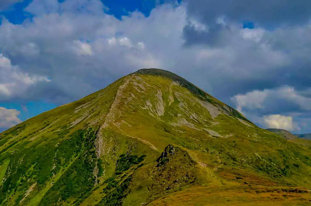
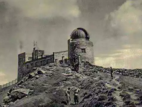
From 1936 to 1938, on the initiative of the Polish government, an astronomical observatory was built on Black Mountain (Pip Ivan Chornohirskyi), at an altitude of 2,028 meters, which at the same time served as a meteorological station. Its walls are made of stone blocks and reach a thickness of one to one and a half meters. The Constructivist building is located on a slope, so it is two-story to the east and five-story to the west. On the southern side of the observatory, there is a round rotunda tower in which the telescope was located.

The materials needed for construction were delivered first by railway to the station Vorokhta, then by forest roads with the help of horses or on foot. It is almost 70 kilometers of the way!

Старі фото обсерваторії білий слон

Photo and video of the “White Elephant” observatory

A brief overview

🗺 Location N48°02’30” E24°37’32”
⛰ Height above sea level 2028 m
🔰 Date of establishment 1938
🏛 Building area 816.26 m2
🛠 Building condition Ruins
🧭 Distance from Lazeshchyna 35 km
🚙 Road for On foot, partly by SUV
🏕 Stop with a tent Yes
🏡 Housing nearby Lazeshchyna
☕ Cafes and shops Lazeshchyna

Current temperature on Mount Pip Ivan:

-3.1o C   |   26.5o F

On the map

History and legends of the “White Elephant” observatory

Before the beginning of the Second World War, the employees of the observatory left the building, taking with them the most valuable, namely: seven lenses from the telescope, two micrometers and the same number of chronometers. All this equipment went to the Budapest Astronomical Observatory in November 1939, and later to Vienna, from where it was transported to Poland after the war.

In September 1939, the Soviet authorities became the new owners of the building. After the partition of Poland, Western Ukraine became part of the USSR. The first high-altitude geophysical observatory and weather station in the Soviet Union was organized here. The observatory resumed its work: constant observations were made, information was transmitted to the forecast bureau in Kyiv.

From 1941 to 1944, a Hungarian military unit was housed in the observatory building.

After the war, the observatory was no longer restored, and the building was gradually destroyed by the local population, tourists and the forces of nature. In winter, when the ruins are covered with ice and bizarre icicles, growths and folds form on the walls, the structure looks very majestic – like a large frozen animal. Perhaps this is why the observatory has a romantic name – “White Elephant”. There is another version of the origin of this name. However, Polish officials considered the construction of the observatory impossible. In their understanding, this project was a “white elephant” – something fantastic, unreal. Today, the building of the observatory is a high-mountain dump and a public toilet, organized by tourists. They often set up tents near it and stay for the night, but it is unpleasant to sleep surrounded by sewage, besides there is no water here. Perhaps in the future there will be investors who will restore the glory of the “White Elephant” and make it a real mecca for tourists.
How to get to the White Elephant Observatory?

Route to the observatory from Hoverla (from the Lazeshchyna side)

🔰 Start Hoverla
🗺 Distance 18 km
⬆ Rise up to 2028 m

The route to the observatory from the village Hoverla

🔰 Start Hoverla Village
🗺 Distance 19 km
⬆ Rise from 648 m to 2028 m

The route to the observatory from Dzembronia

🔰 Start Dzembronia
🗺 Distance 9 km
⬆ Rise from 722 m to 2028 m

Route to the observatory from the village of Zelene (Shybene)

🔰 Start Shybene
🚙 Distance on foot and by SUV 11.5 km
⬆ Rise from 851 m to 2028 m

What is interesting nearby

Other interesting places

Етно-парк «Полонина Перці» в Яблуниці
"Polonyna Pertsi" is the most interesting place for a family rest in Yablunytsya. This incredibly picturesque meadow has become a
Гора Хом’як
Mount Khomyak is located at a distance of almost 6 km from the village of Tatariv and is part of
Музей гуцульського побуту у Татарові
This ethnographic museum is located in the village of Tatariv on the territory of the Koruna recreation complex. The museum's
Музей історії та старожитностей Татарова
To get a deeper insight into the history and traditional way of life in Tatariv, it is worth visiting the
Гора Костел
Among the mountain peaks around Mykulychyn, the first one worth climbing is the majestic Mount Kostel (also known as Horhan
Гора Ягідна
Another mountain peak near the village of Mykulychyn that is definitely worth a visit is the 1,216-metre-high Yahidna Mountain. It
Гора Рокита Велика
While holidaying in the village of Mykulychyn, you should definitely find time to travel to the top of the mighty
Гора Маковиця
If you intend to climb to the top, which was the scene of fierce battles, the best option near Mykulychyn
Чемегівський каньйон
The extremely picturesque Chemehivskyi Canyon has become a very popular natural location in the village of Mykulychyn. Instagram bloggers and
Водоспад Капливець
The Kaplyvets waterfall is located 5 km from the Mykulychyn railway station. It is located on the territory of the
Нарінецький водоспад
The Narinetskyi single-cascade waterfall is 10 metres high. It is located between the villages of Mykulychyn and Tatariv in a
Велика карпатська гойдалка
On the outskirts of Mykulychyn village, you can ride one of the most famous swings in Ukraine. It is located
Броварня “Микуличин”
One of the symbols of Mykulychyn village is the famous Mykulychyn Brewery. It was opened relatively recently - in 2002.
Церква Пресвятої Трійці у Микуличині
In the middle of the nineteenth century, it was decided to build a new wooden church in Mykulychyn not far
Музей етнографії та екології Карпатського краю
At the end of your visit to the museums in Yaremche, you should definitely visit the Museum of Ethnography and
Музей мольфарства у Яремче
Fans of mysticism and magic should definitely visit the Museum of Molfarism in Yaremche. It features ancient household items used
Петропавлівська церква (Музей Шептицького)
While holidaying in Yaremche, tourists will be interested in visiting the modern wooden church of the Holy Apostles Peter and
Екопарк «Ведмежа гора»
Not far from the mini-zoo in Yaremche, there is another interesting location with animals - an eco-park with a petting
Парк-музей «Карпати в мініатюрі»
This unique museum attracts tourists like a magnet. It was initiated in 2015 by the Carpathian National Park and the
Фермерське господарство «Полонина Маковиця»
When you are on holiday in Yaremche, you should definitely visit the cheese dairy of the Polonyna Makovytsia farm to
Гора Синячка
Mount Synyachka, with a height of 1400 metres, is located 20 km from Yaremche. It takes 6 hours to get
Скеля «Слон» у Яремче
At a distance of only 5.5 km from the centre of Yaremche, there is the Elephant Rock, which is formed
Скеля Білий Камінь
The White Stone Rock is located on the outskirts of Yaremche (the northern part of the city is called Dora).
Скелі Довбуша
The rock and cave complex Dovbush's Rocks is located 7.7 km from the central part of Yaremche, Ivano-Frankivsk region, in
Міні-зоопарк «Вольєрне господарство Карпатського національного природного парку»
If you come to Yaremche with children, you should definitely visit the local mini-zoo. It was established in 1992 with
Дорога на гору Говерла
Mount Hoverla is located within two Ukrainian regions - Transcarpathia and Ivano-Frankivsk, and it is 17 kilometers from the border
Легенда гори Близниця
The highest mountain in the Svydovets range of the Carpathians is Mount Blyznytsia, which is 1881 metres high. One of
Природний заповідник Горгани
"Gorgany" is a nature reserve in the Ukrainian Carpathians. It is located in the southwestern part of the Ivano-Frankivsk region,
Женецький Гук
Zhenetskii Huk (Zhenetski Vodospad) is a waterfall in the Ukrainian Carpathians, on the Zhenets stream (a left tributary of the
Музей звичаєвої символіки Гуцульщини
This museum is the most popular in Mykulychyn. Its visit is included in most excursion routes around the village. The
Чорногора
Chornogora is the highest mountain massif of the Ukrainian Carpathians, it includes the town of Hoverla, the highest point in
Озеро Несамовите
Lake Nesamovyte, located on the slope of Mount Turkul, attracts the attention of tourists on the northeastern slopes of the

Tours and excursions

Accommodation nearby

Готель «Мисливська вежа»
with. Lazeshchyna, 788, Zakarpattia region.
+380 ....
from 1540₴/night
Садиба «Смерека» у Яблуниці
H09 road, Yablunytsia village
+380 ....
from 512₴/night

Leisure nearby

Колиба «Злагода»
986 Tsentralna St., Lazeshchyna village, Zakarpattia region, Ukraine, 90633
+380 ....
Ресторан «Корона Карпат»
St. Tsentralna, 1175, p. Lazeshchyna, Transcarpathian region, Ukraine, 90633
+380 ....